The Golden Circle in Iceland – the complete guide
What is the Golden Circle in Iceland?
Golden Circle in Iceland is a tourist circuit close to the capital Reykjavik, comprising 3 major sites and a number of secondary sites. The route is favoured by visitors on short breaks or stopovers between Europe and the United States. It offers a condensed view of Iceland, its geology and its landscapes.
Iceland, its volcanoes, climate and history
Iceland is an island lost on the edge of the North Atlantic. Its geographical position makes it a unique place in the world! Located between two tectonic plates (Eurasian and North American), on the mid-Atlantic ridge, Iceland is a hotbed of volcanic activity.
Iceland is also located at the crossroads of a gulf stream (a warm ocean current arriving from the south-west) and the polar winds from the north.
Iceland’s climate is unstable. A big blue sky can quickly give way to a snowstorm or hailstorm. Visiting the island means being well equipped and regularly checking the weather forecasts and road conditions (websites such as road.is are essential for tourists and locals alike).
In summer, temperatures in Iceland rarely exceed 15°C, with lows sometimes approaching 0°C. But if you’re travelling to Iceland In winter, you should know that there is permanent frost, even if there is not necessarily a lot of snow.
In Iceland, the difference between the forecast temperature and the actual temperature can be as much as 25°. In other words, don’t rely solely on the temperature announced by forecasting websites. You also need to look at the wind speed and direction. A north-easterly wind with a speed of over 30km/h is bound to produce very low temperatures, so beware!
Humans have long been unaware of Iceland’s existence. The date of its colonisation is a matter of debate, but it was in the 9th century that the island was first inhabited by Irish monks. Vikings arrived a few decades later, before settling permanently with the arrival of Flóki Vilgerðarson (Floki the raven, for fans of Viking mythology 🙂 ).
Since then, the island has been transformed, trees have been cut down and towns and villages have been built. But one thing remains: nature, volcanoes, glaciers and winds still rule the island. Regular volcanic eruptions humble Icelanders in the face of nature’s omnipotence.
After passing through Norwegian, Danish, British and American domination/occupation, Iceland has been an independent republic since 1944 and the end of the American invasion of the Second World War. But we’ll see later why Iceland is certainly Europe’s leading democracy.
Sommaire
Visiter le cercle d’or

Þingvellir National Park, a place steeped in history
The Parliament Plains, or Þingvellir (Thingvellir), is certainly Iceland’s most historic place!
Situated on the Mid-Atlantic Ridge, between the North American and Eurasian plates, this national park is where the first European parliament was founded.
Alþing, or Europe’s first democracy
Following the colonisation of Iceland by the Norwegians, Scots and Irish, the creation of an assembly became an imperative for the population. The lack of cultural links between the settlers and the land disputes made this project essential. In 930, an assembly of 36 local chiefs, the Alþing (parliament), met in Thingvellir, formalising the creation of the Free State of Iceland.
Today, the Icelandic parliament has been moved to Reykjavik, where it sits in a large building.

Almannagjá fault and the geology of the park
The Thingvellir plain is a depression surrounded by volcanoes and highlands. In fact, it is a remnant of the very birth of Iceland. The separation of the North American and Eurasian plates created a pocket of magma in the fault. When this magma erupted and submerged in the ocean, land eventually emerged, giving rise to the island of Iceland, the link between Europe and America.
It is at the Almannagjá fault, some forty metres deep, that the separation of the continents is most visible. It is also one of the few places where a fault protrudes. The fault is visible from the north of Lake Thingvallavatn, at the national park car park, so you can’t miss it! You can then follow the fault as it heads north-east.
The Almannagjá is just a small visible part of the rift that crosses Iceland from south-west to north-east. This is the landscape that best explains Iceland’s geology.

The park is also close to the Langjökull glacier. The water in Thingvellir and Lake Thingvallavatn (Iceland’s largest lake) comes from the melting of this glacier. It is famous for its clarity. In fact, before it reaches the park, it flows through underground volcanic lava, which filters it and turns it into pure water.
You can go diving in Iceland, in Thingvellir Park. The Silfra Fault is popular for its diving activities and crystal-clear water, with visibility of up to 100 metres. Companies such as Arctic Adventures offer excursions from Reykjavik. The programme includes between 4 and 6 hours of diving in the depths of the fault. Note that a good level of diving is required for this type of activity. Otherwise, you can opt for snorkelling, which is a unique experience!
Flora and fauna of Thingvellir National Park
The last volcanic eruption around Thingvellir Park took place just 2,000 years ago. As you travel through the park, you’ll come across lava fields covered in moss and lichen. But the region’s special feature is the presence of Iceland’s largest forest area. A reforestation plan has enabled the birch trees, endemic to the island, to flourish once again and form forests not usually seen in Iceland.
It should be noted, however, that non-endemic trees, notably conifers, have been introduced into the park.
As for the fauna, as everywhere else in Iceland, the polar fox is the only endemic mammal. You may come across it in the park, but it is rare and very discreet.
A few other mammals introduced by man, such as the field mouse and the American mink, can be seen in the park.
Thingvellir National Park is most famous for its fifty or so species of aquatic and non-aquatic birds. You can spot the Barrow’s goldeneye, the long-tailed duck and the red-throated loon. If you’re lucky, you’ll come across the mythical gyrfalcon or the many rock ptarmigan that inhabit the region.
Small, shy birds such as the red-necked phalarope enjoy the parts of the park where the water is shallow.
Finally, the short-eared owl, one of the rare representatives of its genus, can be seen in the park.

Hiking in Thingvellir National Park
Numerous trails have been created in the park to enable visitors to explore it. You can download the Thingvellir hiking map and create your own route. But the most popular walk is the one that starts at the information point and takes you along the Almannagjá fault to the Oxarárfoss waterfall. The round trip takes around 1? hours. The level of difficulty is easy.
It’s worth noting that this hike in Thingvellir passes through the filming locations of the famous Game of Thrones series. If you’re a fan, you may recognise some of the scenery.

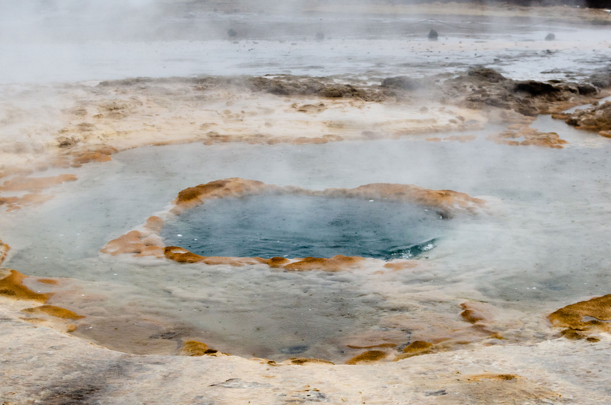
Geysir, a geothermal field just outside Reykjavik
You’re probably familiar with the term geyser, which refers to a spring from which hot water gushes out at a greater or lesser height. The Engish word comes from the Icelandic Geysir, the name of an Icelandic hot spring and the geothermal field where it is located.
The life of Geysir is made up of periods of activity and periods of sleep. In 1845, water gushed from Geysir at a height of 170 metres. In 2000, the water reached a height of 122 metres. It’s the highest geyser in the world!
Today, Geysir’s activity is reduced, with only three eruptions a day. Its neighbour, the Strokkur spring, on the other hand, gushes out every 10 minutes at a height of up to 40 metres.
Incredible as it may seem today, the Geysir geothermal area was once privately owned by a wealthy whisky distiller and Prime Minister of Northern Ireland. Until 1935, when the field was bought by Sigurdur Jonasson, a film-maker who returned ownership of Geysir to the Icelandic people, access was charged. Since then, the local population has taken steps to protect the area, both legally and environmentally.

The Geysir geothermal field is around 150km from Keflavik international airport (allow two hours to get there), and around 100km from the capital Reykjavik. There are Reykjavik-Geysir buses and companies offering day trips to the Golden Circle.
If you do the whole Golden Circle circuit, then Iceland’s geyser will be your second destination after Thingvellir National Park. You’ll need to keep heading east on Route 37 for 47km.
As you approach the Geysir geothermal field, the landscape will gradually change. You will see fumaroles, a sign of strong geothermal activity.
Once in the Haukadalur valley, where Geysir is located, you’ll see large columns of smoke. Open your eyes wide and enjoy the incredible colours of the minerals – the landscape is well worth a visit!

Swimming at Geysir is prohibited. The high temperature and the composition of the water make swimming dangerous, including in small pools such as the Blue Eye. There is also a risk of sinking into the mud in certain areas. So make sure you stick to the marked section!
Finally, the Icelandic geyser is generally accessible in winter, except in the event of an exceptional storm. Route 37 is regularly cleared of snow to allow visitors access to the geothermal zone.
Gullfoss waterfall or the rainbow waterfall!

Gullfoss means “golden waterfall” in Icelandic. When the sun shines, a rainbow appears in front of the waterfall. The power of the waterfall is then punctuated by a touch of softness. A surreal landscape that has made the reputation of this very popular spot, the third and last site in Iceland’s Golden Circle.
The Gullfoss waterfall, located on the Hvítá river, consists of two jumps, the first 11 metres high and the second 21 metres. The Hvítá river, which is very wide at this point (around 70 metres), flows into the Hvítárgljúfur gorge for several kilometres.
The power of the Gullfoss waterfall caused erosion in the gorge. Today, it continues to cut through 25cm of rock every year.
Gullfoss is just 10km from Geysir. Ideally, you should plan to visit the waterfall just after the Geysir geothermal field, by continuing east on Route 35. Along the way, you can make a few stops along the banks of the river Hvítá.
Structures have been built around Gullfoss. Don’t hesitate to use them to see the waterfall from different levels. The best view (and the least wet 🙂 ) is from the upper level. From this level you can go to the Gullfoss Panorama Restaurant, which serves kjötsúpa, a traditional Icelandic meat broth.

Where to sleep around Gullfoss?
As Gullfoss is very close to Geysir, you can read our tips for sleeping around Geysir.
Another option is the Hotel Gullfoss, just 3km from the waterfalls. But you’ll need to pay €200 for a double room.
Given the limited options around Gullfoss, if you want to find cheap accommodation, I’d advise you to leave the area to sleep.
Some tips if you visit Gullfoss
The winds are often strong around Gullfoss. So make sure you bring waterproof clothing if you don’t want to get completely soaked. Even from a distance you can’t escape the spray!
In winter, there can be a lot of ice and some places can be slippery. To be on the safe side, all you need is a pair of small crampons. I’d advise you to bring some with you to Iceland, as some tourist sites are impassable without crampons.
Finally, it can get very crowded at the Gullfoss waterfall. If you want to take photos of the waterfall and avoid the tourist buses, it’s best to go at the very beginning or very end of the day.

The incredible story of Sigríður Tómasdóttir
If the Gullfoss waterfall still exists today and is part of the Golden Circle, it’s thanks to one woman, Sigríður Tómasdóttir, and her story is quite incredible!
At the beginning of the last century, the Icelandic government decided to build a dam and power station to harness the power of Gullfoss. At the time, the land on which the waterfall is located belonged to Sigríður Tómasdóttir’s father. This structure would have made the two waterfalls disappear into the reservoir.
Refusing to see Gullfoss disappear, Sigríður Tómasdóttir began a long battle against the project. On numerous occasions, she walked to Reykjavik (120 km in difficult conditions) and pleaded the environmental cause. She even threatened to end her life by throwing herself into the waterfall.
In the end, the Icelandic parliament gave in to Sigríður Tómasdóttir’s determination. Sveinn Björnsson, who went on to become the first president of the independent Republic of Iceland, supported Sigríður in her bid to have the Gullfoss waterfall declared a national asset.
Today, a monument to Sigríður Tómasdóttir has been erected in front of the waterfall.
Gullfoss love story
Iceland is a land of stories and myths, and Gullfoss is no exception. In the 17th century, two families lived on either side of the river Hvítá.
On the west bank, Þórður Guðbrandsson, son of the farm owner, took his sheep to graze by the river.
On the east side, Guðrún Þóroddsdóttir, daughter of the farm owner, took the sheep to graze by the river.
Þórður and Guðrún got to know each other by talking on different sides of the river. Over the years, they became close friends. Þórður declared his love for Guðrún, who replied that she would marry him if he would cross the dangerous river of Hvítá. Þórður immediately jumped into the water and risked his life to cross the rapids. When he reached the other bank, Guðrún was waiting with arms wide open to warm him.
Þórður and Guðrún married in Skeiðar in 1690 and enjoyed a long love affair.
When is the best time to visit the Golden Circle?
The Golden Circle is accessible all year round, but the scenery is very different from one season to the next.
In winter, the Gullfoss waterfall is surrounded by ice. It’s even difficult to stand in front of the waterfall because the winds are so strong and the cold is so wet and biting. Thingvellir national park is covered in snow and ice. The hiking trails are still accessible, however, and can often be done in walking boots. On the other hand, nothing changes for Geysir, where the high temperatures under the ground melt the snow and ice.
In spring and summer, the vegetation abounds, the colour green dominates the landscape and the forests of Thingvellir are majestic.
In autumn, the blueberries and heather change colour, covering the landscape in a coat of red and orange. For me, this is the best time to visit Thingvellir Park and the Gullfoss waterfall.
You’d be amazed at how the Golden Circle changes completely from one season to the next. The greenery of summer gives way to the incredible colours of autumn before the ice freezes everything in place, as if to remind you that Iceland borders the Arctic Circle.
Visit the Golden Circle from Keflavik
If you’re visiting Iceland, you’ll probably arrive at Keflavik airport, in the south-west of the country. This is your point of departure, and you’ll need to get organised from there.
How long does it take to visit the Golden Circle?
The Golden Circle can be visited in a day, but I’d advise you to allow two days if you want to enjoy the region, go hiking and stop en route to take in the beautiful scenery.
Where to stay around the Golden Circle?
To the east of Thingvellir National Park lies the Hotel Laugarvatn. Ideally located, the hotel offers double, 3-bed and 4-bed rooms at affordable prices (everything is relative, we’re talking about Iceland). A three-bed room, for example, costs €160, or just over €50 per person. This has become a rarity in Iceland!
If, on the other hand, you’re returning to Reykjavik at the end of the day, I’d recommend the Kex hostel, which offers accommodation ranging from double rooms to 42-bed dormitories. The rates are the lowest in Reykjavik. The Kex is also a pub where you can order pizzas or beer and enjoy live music or quizzes on certain evenings.
Finally, if you’re looking for something a little more luxurious, then the ION Adventure Hotel could be for you. It is located on the shores of Lake Thingvallavatn. Expect to pay around €300 per night.
What to visit around the Golden Circle?
There’s always something to do in Iceland. The light so sublimates the landscapes that the smallest rock becomes majestic. In Iceland, every day is unique. When you visit the Golden Circle, let yourself be surprised by what surrounds you. Reading a travel guide is one thing, but you have to live your own, find your own places, marvel at the moments that will make you your own.
During your trip to the Golden Circle, take the time to explore. The tourist spots have nothing to envy to the lost places where nobody goes!
The secret lagoon
Just 25km south of Geysir is the Secret Lagoon. You can take advantage of your trip to the Golden Circle to relax for a while. These hot-water baths are the oldest in Iceland. They were built by the inhabitants of the village of Flúðir to take advantage of the geothermal activity in the region.
Admission to the secret lagoon costs around €23. I’d advise you to avoid peak tourist times, which in Iceland are between midday and 2pm and 6pm. Instead, opt for a trip at the end of the day to enjoy a beautiful sunset in the warmth of 40°C water.
Kerið crater
Kerið is a volcanic crater located to the south of Thingvellir National Park. A deep blue lake has formed at the bottom of the crater. The crater was formed only 3,000 years ago. The rim of the crater is made of a surprisingly red rock.
Kerið crater is privately owned. As a result, there is a parking charge (around 3$).
Last but not least: I would advise against visiting Kerið between October and April. In winter, the crater is covered in snow and the lake is frozen. In other words, all you’ll see is a white mountain.
Rent a car in Keflavik
When you arrive in Iceland, at Keflavik airport, it’s best to hire a car locally rather than in Reykjavik. The rates are often better, and you’ll save on bus fares (around 35$ a way between Keflavik and Reykjavik…).
Personally, I use the Carjet car hire site, which gives me the lowest rates in Iceland.
At the end of your stay, simply return your car to Keflavik and walk to your terminal. In most cases, you’ll only have to walk a few hundred metres.
Hiring a car to visit the Golden Circle, or Iceland in general, requires a debit card rather than a credit card. While in France there is no difference between the two, in Iceland your credit card may be refused. Another solution would be to pay for the car in full online, taking out comprehensive insurance.
Icelandic cars generally have automatic gears. If you’ve never driven an automatic car before, take the time to get used to it before setting off on the main roads, as the lack of a clutch can be disorientating.
Outside the summer months, Icelandic cars are systematically hired out with winter tyres. Don’t be surprised if you see nails on your tyres – it’s not a puncture, but studded tyres! These tyres reduce the risk of skidding. However, be careful in winter, as speed should be adapted to the presence of ice on the roads.
Finally, in certain areas, black sand or volcanic ash can damage your windscreen and even the bodywork. If you drive through a vast expanse of black sand, reduce your speed, especially if the winds are strong.